Satellite image classification is a powerful technology. It uses algorithms to analyze and categorize different elements within images taken from space. It's like giving our military "eyes in the sky" that can understand what they're seeing.
In the military, this means quickly identifying and understanding key features on the ground. This includes things like enemy positions, vehicle types, and changes in terrain. This information is crucial for planning and executing operations.
Satellite image classification helps transform raw images into actionable intelligence. It enhances situational awareness, which is vital for strategic decision-making.
There are several types of satellite imagery used. Multispectral imagery captures data across multiple wavelengths, including beyond the visible spectrum. Panchromatic imagery captures a wide spectrum of light in one band, producing high-resolution black and white images, as mentioned in ABI Research's article.
Synthetic Aperture Radar (SAR) uses microwave signals to produce high-resolution images. SAR can penetrate clouds and darkness. Each type provides unique data, contributing to a comprehensive understanding of the operational environment.
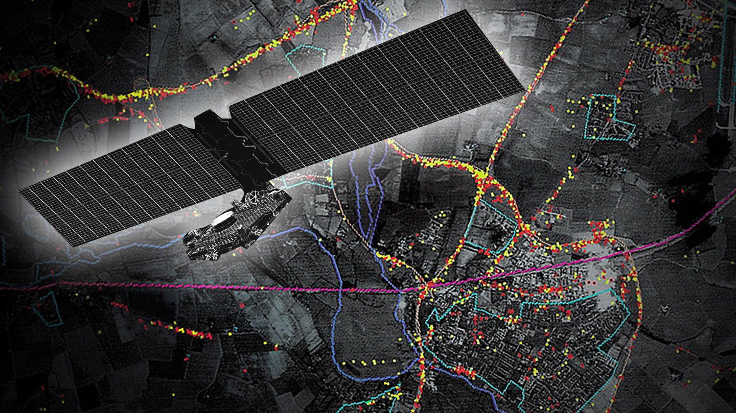
The use of satellite image classification in defense is revolutionizing military strategies. This technology provides critical insights that were previously unattainable.
Satellite imagery allows for continuous monitoring of areas of interest. Military forces can observe enemy movements, track assets, and detect unusual activities in real time. This capability is essential for maintaining a strategic advantage.
For instance, during the Russia-Ukraine conflict, Sentinel-1 satellites provided real-time data on troop movements. They were vital for assessing potential threats, as noted in ABI Research's report.
Identifying and tracking specific targets is another crucial application. AI and machine learning algorithms can detect vehicle types, aircraft, ships, and military hardware. It minimizes collateral damage when striking a target.
This technology enhances the precision of military operations. It ensures that only intended targets are engaged.
After a military operation, satellite imagery helps assess the damage inflicted. Defense agencies can evaluate the effectiveness of their actions. They can plan subsequent steps.
This capability is crucial for post-conflict recovery. It aids in rebuilding efforts. Satellite imagery can identify areas most affected by conflict, as seen in studies of structural damage in Syria.
Environmental monitoring is vital during conflicts. Satellite imagery can track oil spills, fires, and other environmental damage caused by military actions. It helps in mitigating the long-term environmental impact of conflicts.
For example, monitoring deforestation and tracking climate change using satellite images can serve as an early warning system. It can help identify areas at risk of desertification, as highlighted by ABI Research.
The integration of satellite imagery analysis into military strategies offers numerous benefits. These advantages enhance operational capabilities and improve decision-making.
Satellite imagery provides timely and accurate data. Commanders can make informed decisions based on real-time intelligence. This capability is crucial in dynamic and rapidly changing conflict environments.
Real-time surveillance allows for quick adjustments to strategies. It ensures that military actions are effective and aligned with the current situation.
Efficiency in military operations is significantly improved with satellite imagery. Resources can be allocated more effectively. Operations can be planned with greater precision.
For instance, the ability to track troop movements and identify key targets reduces the time and resources needed to achieve objectives. It minimizes risks to personnel.
Using satellite imagery is often more cost-effective than traditional reconnaissance methods. It reduces the need for manned missions. It also lowers the risk to human lives.
The initial investment in satellite technology can lead to long-term savings. It provides continuous and extensive coverage.
Satellite imagery reduces the need for personnel to be physically present in dangerous areas. Reconnaissance can be conducted remotely. This minimizes the risk of casualties.
This capability is particularly valuable in high-threat environments. It allows for effective monitoring without endangering troops.
Despite the numerous benefits, there are several challenges in using satellite image classification for military purposes.
The sheer volume of data generated by satellites is immense. Processing and analyzing this data requires significant computational power. Advanced algorithms are essential.
Managing this data influx is a major challenge. It requires robust infrastructure. Organizations must invest in high-performance computing resources.
Ensuring the accuracy of classification algorithms is critical. Errors can lead to incorrect intelligence. This could compromise missions.
Continuous refinement and validation of algorithms are necessary. This ensures they perform reliably under various conditions. The algorithms must adapt to new scenarios.
Integrating satellite imagery analysis into existing military systems can be complex. It requires seamless data flow between different platforms. Compatibility issues must be addressed.
This integration is crucial for effective utilization of satellite intelligence. It ensures that data is accessible. Decision-makers can use it when needed.
Security of satellite data is paramount. Unauthorized access can compromise sensitive information. Protecting data from cyber threats is essential.
Privacy concerns also arise. The use of satellite imagery must comply with international laws and ethical standards. Balancing security needs with privacy rights is a delicate task.
The field of military satellite image processing is rapidly evolving. Several future trends are poised to enhance its capabilities further.
AI and machine learning are set to play an increasingly significant role. These technologies can automate complex analyses. They provide more accurate and timely intelligence.
For instance, deep learning models can improve the detection of subtle changes in satellite images. They can identify patterns that humans might miss. This enhances the overall effectiveness of military operations, as discussed in the article on aircraft detection in satellite imagery using deep learning.
The deployment of proliferated satellite constellations is another major trend. These constellations consist of numerous small satellites. They provide continuous and extensive coverage of the Earth.
This approach enhances resilience and flexibility. It ensures that data is always available. It also reduces the impact of losing a single satellite.
Future satellite imagery will feature enhanced multispectral and hyperspectral capabilities. These technologies capture data across a wider range of wavelengths. They provide more detailed information.
This capability allows for better identification of materials and objects. It improves the accuracy of classification. It also supports more sophisticated analyses.
Collaboration with commercial satellite providers is increasing. This partnership leverages the capabilities of the private sector. It provides access to cutting-edge technology and data.
This collaboration can enhance the military's access to high-quality imagery. It also fosters innovation. It drives advancements in satellite technology.
Satellite image classification is transforming military strategies. It provides unparalleled insights and enhances operational capabilities.
The integration of satellite imagery into military operations has numerous benefits. It improves decision-making, operational efficiency, and cost-effectiveness. It also increases personnel safety.
While challenges exist, ongoing advancements in technology are addressing these issues. They are paving the way for even greater capabilities in the future.
The future of military satellite technology is promising. Advances in AI, the development of proliferated constellations, and enhanced imaging capabilities will further revolutionize military strategies. Understanding satellite image classification and its benefits will remain crucial.
Collaboration with commercial providers will continue to drive innovation. It ensures that the military has access to the best available technology. The vision is for a more connected, informed, and effective defense capability, leveraging the full potential of satellite imagery.